|
CIAT and partners completed the third version of their population
database for Latin America and the Caribbean in March 2005.
This web site presents the results of that effort, including
digital maps available for download and new documentation
reflecting the latest additions and updates to the database.
The new version now contains population data from over 18,300
administrative units in the region. New population totals
from recent censuses were incorporated for more than 20 countries.
The population distributions were estimated using improved
spatial data. This initiative is part of continuing efforts
to improve the capacity to understand the geographic dimensions
of population in Latin America and the Caribbean.
In
Latin America and the Caribbean, population grew from 166
million people in 1950 to 513 million in 2000, and is expected
to increase to over 800 million by 2050 (Figure 1). Population
growth is putting new pressures on less developed areas, like
the Amazon basin, where urban areas have grown considerably.
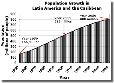
Figure 1. Population Growth in Latin America
and the Caribbean.
Decision-makers, researchers and others interested
in demographic dynamics need population data for a broad
range of analyses in many fields. CIAT's Latin America
and Caribbean Population Database provides geographic
and historical information on population in the region.
Digital population maps are increasingly used in environmental,
demographic, agricultural and economic analysis. The development
of this database supports the needs of researchers and analysts
to make broad-scale analyses of population for Latin America
and the Caribbean. Applications of the data set in the agricultural
sector include analysis of the relationship between population
growth and agriculture in developing countries, the impact
of population pressure on food security, and analyses of the
effects of climate change on the rural sector. Key applications
of population data for environmental analysis include the
impact of population growth on biodiversity, land degradation
and resource use. The range of applications for demographic
research is extensive, including analyses of urbanization,
fertility and migration. Researchers rely on population data
to identify people at risk for natural and human-made disasters.
This information resource includes estimates of population
between 1960 and 2000 for the 44 countries in Latin America
and the Caribbean. The database is part of larger efforts
by CIAT and partners to map global population

|
